Should there be a new North Downs National Park and are the Malvern Hills Britain's original prototype National Park?
These are the questions that prompted the promotion of a two new National Parks for both the Malvern Hills and the North Downs. In the first quarter of the 21st century we formulated proposals that developed these ideas and published them on line as well as pursuing them through the various relevant authorities and organisations. In 2026 these ambitions had come to partial fruition. To make this practical a new designation was created - "National Landscape". This in effect gave a landscape the same protection as a National Park but did not include a new National Park Authority.
- scroll down to our British National Parks INDEX and consider the arguments.
The modern perception of a National Park resulted from pre-war measures to protect the countryside and to provide access for the urban population of
Britain's industrial towns and cities. The Second World War delayed the implementation of such designation although detailed proposals were well advanced. After the war there was great deprivation as we recovered from the conflict and the new National Parks were seen as something that was worth fighting for with the associated sacrifice of life. The year 1951 saw a number of designations confirmed and the National Park movement was at last underway. 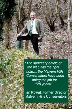
Or was it that simple? No, the Victorians had got there a lot earlier in the 19th century. Although not named a National Park, the Malvern Hills could arguably be called
Britain's original National Park, being established with its own statutory administrative body and countryside protection initially under an Act of Parliament of 1884 with subsequent amendments. With its priorities on public access and conservation, the
Malvern Hills were well established as a specially protected area by the dawn of the 20th century. The Malvern Hills Conservators (now called the Malvern Hills Trust) were empowered by an Act of Parliament that enabled them to resist everything from intrusion by major new road schemes, water company projects and urbanisation. In addition access by the public was and remains top of their agenda.
A similar argument to that above applied to the North Downs where Banstead Commons are managed by a body of Conservators. This status was used in the proposal for a new North Downs National Park.
CLICK THE LOGOS BELOW TO GO INTO THE WEB SITE OF THE ADMINISTERING BODY.

Geographical Location - Southern England
Population - undecided
Proposedl Date of Designation: Conservation Board by 2020. Full National Park status confirmation - 2025.
Administered by - North Downs National Park Authority.
Area - undecided but about 1492 square kilometres
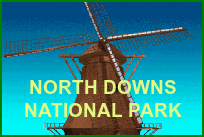
This was a proposal for a North Downs National Park to the south of London. The preliminary maps featured on this web site (click the windmill logo above) set out an area stretching from Hampshire, through Surrey to Kent, following the line of the North Downs escarpment. The central location was seen as Tadworth in Surrey which is noted for its extensive 'freedom to roam' downland landscape in the immediate vicinity. The site of Tadworth Mill and adjacent buildings was proposed as the ideal position for a National Park Centre with the windmill becoming an iconic landmark and logo for the National Park.
The more recent implementation of the National Landscape designation however resulted in the historic Areas of Natural Beauty being designated as National Landscape. This provided a series of island sites along the length of the North Downs whereby protection was enabled. This first stage was then followed by a second that joined up the island sites to make it a continuous National Landscape designation along the length of the North Downs. Within this, individual managing organisations retained their original status.

Geographical Location - Southern England
Population - 108,000
Date of Designation Confirmation - 2010
Administered by - South Downs National Park Authority from 1st April 2011.
Area - 1,625 square kilometres
 Click the Sussex University Armorial left to read "Tourism and the Sussex Downs", the major study that was instrumental in orchestrating National Park status for the South Downs.
Geographical Location - South Wales
Population - 2,200
Date of Designation Confirmation - 1957
Administered by - Brecon Beacons National Park Authority
Area - 1,344 square kilometres

Geographical Location - West Midlands
Population - 29,000

Although not named National Park, the Malvern Hills could arguably be called Britain's first National Park having been established with its own statutory administrative body and countryside protection initially under an Act of Parliament of 1884 with subsequent amendments.
On an International level, the definition of a National Park includes the inalienable status of the land. This is achieved by the park area being owned by the nation for the nation, with appropriate legislation that curtails the inappropriate management of the land. In this respect the Malvern Hills are more a National Park than the 15 designated British National Parks. In the 15 British cases, the land is largely privately owned but the National Park legislation curtails the rights of the landowner to develop and manage their land unhindered. However with the Malvern Hills, some of the land is owned by the Malvern Hills Conservators (now called the Malvern Hills Trust), representing the Nation, with statutory obligations to manage their land within strict parameters. By owning the land area, the Malvern Hills is nearer to the International model than the so named British National Parks.
Administered by - Malvern Hills Trust, formerly Conservators
Area - 12 square kilometres
Historically therefore was the general acknowledgement that formal National Park designation should be pursued for the Malvern Hills and surrounding landscape. This could include the Teme Valley to the north, as well as Abberley Hills Geopark. Much of this area was designated great landscape value (AGLV). It was noted not only for its archetypal English countryside appearance but also its distinct geology and attraction to tourists.
The creation of the National Landscape designation in 2026 however has resulted in a substantial Area of Natural Beauty being re-designated National Landscape. It includes the range of Malvern Hills. Great Malvern and Ledbury become the Gateway Towns for visitors. The area stretches from Knightwick in the north, to the M50 motorway in the south. On the eastern side, Great Malvern provides the boundary while on the West, Ledbury does similar. It includes the Malvern Hills Conservators/Trust lands which remains under their control.
Click the logo above for details of the Malvern Hills National Park proposal.
The proposal above was developed before the creation of the National Landscape designation in 2026 which was then applied to the Malvern Hills Area of Outstanding Natural Beauty. It is seen as the first step in the reorganisation of the Malvern Hills as a National Park. The National Landscape offers similar protection to that of a National Park but does not have an Authority managing it like a National Park. The Malvern Hills Trust are seeking to revise their powers over their land and this is an ongoing matter and concern for some. Therefore full National Park status should now be considered appropriate in which case the Trust/Conservators may be converted to a National Park Authority. In view of this we continue to promote the establishment of a new Malvern Hills National Park on-line as above.
Click the University of Sussex Armorial left to read the Malvern Hills case study in the Sussex Downs Tourism study.
Geographical Location - South West England in the county of Devon
Population - 29,000
Date of Designation Confirmation - 1951 (Britain's oldest National Park)
Administered by - Dartmoor National Park Authority
Area - 954 square kilometres
Click the University of Sussex Armorial left to read the Dartmoor case study in the Sussex Downs Tourism study.
Geographical Location - South West England in the counties of Somerset and Devon
Population - 10,640
Date of Designation Confirmation - 1954
Administered by - Exmoor National Park Authority
Area - 693 square kilometres
Geographical Location - North West England in the county of Cumbria
Population - 42,200
Date of Designation Confirmation - 1951
Administered by - Lake District National Park Authority
Area - 2,292 square kilometres
Geographical Location - In the extreme North of England in the county of Northumberland
Population - 2,200
Date of Designation Confirmation - 1956
Administered by - Northumberland National Park Authority
Area - 1,049 square kilometres

Geographical Location - Far north of England in the county of Yorkshire
Population - 25,500
Date of designation Confirmation - 1952
Administered by - North York Moors National Park Authority
Area - 1,436 square kilometres

Geographical Location - At the southern end of the Pennines in central England
Population - 38,100
Date of Designation Confirmation - 1951
Administered by - Peak District National Park Authority
Area - 1,438 square kilometres
Geographical Location - South Wales peninsula in the county of Dyfed
Population - 22,800
Date of Designation Confirmation - 1952
Administered by - Pembrokeshire Coast National Park Authority
Area - 620 square kilometres
Geographical Location - North West Wales in the county of Gwynedd
Population - 26,200
Date of Designation Confirmation - 1951
Administered by - Snowdonia National Park Authority
Area - 2,176 square kilometres
Geographical Location - Astride the Pennines in the North of England
Population - 17,900
Date of Designation Confirmation - 1954
Administered by - Yorkshire Dales National Park Authority
Area - 1,762 square kilometres
Geographical Location - On the lowlands of East Anglia in the East of England in the counties of Norfolk and Suffolk
Population - 2,200
Date of Designation Confirmation 1989
Administered by - Broads Authority
Area - 303 square kilometres
Geographical Location - Southern England
Population - 34,000
Date of Designation Confirmation - 2005
Administered by - New Forest National Park Authority
Area - 670 square kilometres

Geographical Location - Scotland, north of Glasgow
Population - 15,600
Date of Designation Confirmation - 2002
Administered by - Loch Lomond & The Trossachs National Park Authority
Area - 1,864 square kilometres
Geographical Location - north-east Scotland
Population - 16,000
Date of Designation Confirmation - 2003
Administered by - Cairngorms National Park Authority
Area - 3,800 square kilometres; the largest in Britain
Further Reading - Smith R (2015) National Parks of Britain, AA Publishing.
(c)2026 SPAS Research Fellowship Terms & Conditions


.png)