| 
|


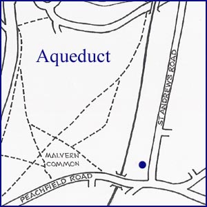
Aqueduct
NGR 78081 44297
Site Number: C82
By Bruce Osborne and Cora Weaver (C) 2012
Area 4. West Malvern Springs and Wells
Malvern Hills, England
Location: in the garden of a modern bungalow in St Andrew's Road
Description: archaeology in a garden near a former railway cutting
In May 1864 a new railway line opened between Great Malvern and Tewkesbury. Where the steam trains ran between Malvern Wells Common and St Andrew's Road they passed through a very deep cutting. The cutting has now been filled in, and the ground is level, so it is difficult today to imagine how it used to look.
Straddling the cutting was an aqueduct. It was made of lead; the bottom was approximately 18 inches wide, and the sides about 10 inches deep. Water flowed through the aqueduct from Malvern Wells Common downhill towards the common on Longridge Road. Each end of the aqueduct was at ground level, so it was easy for children to get on to. Which is what they did. In the 1930s one local lady recalls bounding effortlessly across it on many occasions. When an evacuee arrived from Birmingham in 1939, she was dared to cross it. She was scared to venture forth but with much urging from other children she cautiously made her way safely to the other side. With hindsight, it is unanimously agreed that if anyone had fallen onto the railway track beneath they would have been killed. Perhaps to the relief of many, the line closed in1952, the aqueduct dismantled, and the cutting filled in, but some old maps marked 'aqueduct' show its exact location.
In the 1930s and early '40s children used to play on the common on Longridge Road, which was dry and sprinkled with harebells and quaker grasses. Towards the end of the Second World War the common was ploughed up to grow wheat and after that the ecology of the common changed. It changed to a wet, boggy common, alive with bog-cotton and water-iris. This may have had more to do with the dismantling of the aqueduct than the ploughing.
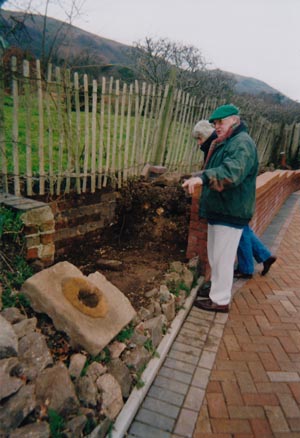
One of the latest discoveries of an unsuspected water feature comes from a local Friend of Malvern Springs and Wells.[1] While exploring the remains of a substantial watercourse flowing through his garden, the owner of a nearby bungalow unearthed a heavy stone slab with an iron inset that looked like the base of a pump. This is believed to have had something to do with the eastern end of the aqueduct, and the watercourse is likely the one that previously had flowed through the aqueduct.
On the other side of the Ledbury-Malvern railway nearby is an enclosure with iron railings. This is a reservoir and may be part of the same water system. There was once a pumping station on the common nearby but in November 1912 the local Council decided to demolish it and sell the materials.[2]
Illustration:
Local Friend of Malvern Springs and Wells displays aqueduct archaeology found in his garden, adjacent to the line of the old railway cutting.
Footnotes:
[1] Friends of Malvern Springs and Wells, Newsletter 7, March 2005.
[2] Minutes of Malvern Urban District Council 3 November 1912.
Website: Click Here
SUPPLEMENTARY INFORMATION

Celebrated Springs of
THE MALVERN HILLS
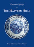 A definitive work that is the culmination of 20 years researching the springs and wells of the Malvern Hills, published by Phillimore. This is the ideal explorers guide enabling the reader to discover the location and often the astounding and long forgotten history of over 130 celebrated springs and wells sites around the Malvern Hills. The book is hard back with dust cover, large quarto size with lavish illustrations and extended text. Celebrated Springs contains about 200 illustrations and well researched text over a similar number of pages, together with seven area maps to guide the explorer to the locations around the Malvern Hills. It also includes details on the long history of bottling water in the Malvern Hills.
Written by Bruce Osborne and Cora Weaver, this book is available on-line for £15.00 (delivered UK) - click Malvern Bookshop on the green panel top left. Alternatively send a cheque payable to Cora Weaver with your name and address to 4 Hall Green, Malvern, Worcs. WR14 3QX.
1) TOPOGRAPHICAL LOCATION:
Malvern Hills - arguably Britain's original National Park
2) LANDSCAPE:
Built Up Location3) INFORMATION CATEGORY:
A Spring, Spout, Fountain or Holy Well Site4) MALVERN SPRING OR WELL SITE DETAILS:
1 SPLASH - Lost - Nothing Much To See
5) GENERAL VISITOR INFORMATION:
On Private PropertyNot Open To Public
Free Parking Nearby