| 
|


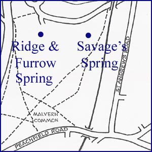
Ridge & Furrow Spring + Savage's Spring
NGR 77549 45809
Site Number: C83:1/2
By Bruce Osborne and Cora Weaver (C) 2012
Area 4. West Malvern Springs and Wells
Malvern Hills, England
Description: two springs in a field
To find these springs head up Thirlstane Road. Pass under the railway bridge and after 200 metres enter the field on your left through a kissing gate. Follow the boundary on your right for about 300 metres until you come to a second kissing gate on the right. Ridge and Furrow Spring is 200 yards to the left as you pass through the gate. As you pass through this gate Savage's Spring is directly in front of you, 200 yards uphill.
In 1633 this field was owned by Mr Savage and was part of Redmore Meadow, which had formerly belonged to Great Malvern Priory. The 1633 Malvern Chase enclosure map shows a parcel of land 49 acres 2 perches 12 roods[1] that was enclosed as part of the King's Third. Today it is bounded on the north by Thirlstane Road and on the south by Malvern Wells Common; by the railway line on the east, and Wells Road on the west. It is enclosed by railings and owned by Malvern College.
Until the mid-nineteenth century Great Malvern was a tiny agricultural village where the majority made their living from raising sheep and growing wheat, barley, peas and fruit. Ox-drawn ploughing results in ridges and furrows, and there is still evidence of ridge and furrow to the east of the village and in this field, south of the village. The ridges are narrower than medieval, ox-drawn ridges, and are probably the remnant of nineteenth century orchards, created so that fruit trees could be grown on the ridges and irrigation water fed into the furrows. The landscape here has been altered, particularly after Severn Trent laid a pipeline across the ridge and furrow c. 2005, but the spring can be seen on the east edge of the ridge and furrow.
Uphill of the ridge and furrow is another spring, which would have been an essential part of successful crop production. Savage's Spring is in the same field but is at NGR 77764 44681. Visible evidence is a damaged 6 inch glazed drain pipe and about 3 metres directly below are two flagstones that are evidence of the course of the spring. Both springs may be part of the watercourse that fed Aqueduct.
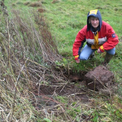
1. Savage's Spring - the higher access point.
2. The Ridge and Furrow Spring site.
3. In 1633 this field was owned by Mr Savage and was part of Redmore Meadow, which had formerly belonged to Great Malvern Priory.(courtesy Malvern Museum)
Footnotes:
[1] There were 4 roods to an acre; 40 perches to a rood.
Website: Click Here
SUPPLEMENTARY INFORMATION

Celebrated Springs of
THE MALVERN HILLS
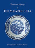 A definitive work that is the culmination of 20 years researching the springs and wells of the Malvern Hills, published by Phillimore. This is the ideal explorers guide enabling the reader to discover the location and often the astounding and long forgotten history of over 130 celebrated springs and wells sites around the Malvern Hills. The book is hard back with dust cover, large quarto size with lavish illustrations and extended text. Celebrated Springs contains about 200 illustrations and well researched text over a similar number of pages, together with seven area maps to guide the explorer to the locations around the Malvern Hills. It also includes details on the long history of bottling water in the Malvern Hills.
Written by Bruce Osborne and Cora Weaver, this book is available on-line for £15.00 (delivered UK) - click Malvern Bookshop on the green panel top left. Alternatively send a cheque payable to Cora Weaver with your name and address to 4 Hall Green, Malvern, Worcs. WR14 3QX.
1) TOPOGRAPHICAL LOCATION:
Malvern Hills - arguably Britain's original National Park
2) LANDSCAPE:
Farmland3) INFORMATION CATEGORY:
A Spring, Spout, Fountain or Holy Well Site4) MALVERN SPRING OR WELL SITE DETAILS:
3 SPLASHES - Of Moderate Interest
5) GENERAL VISITOR INFORMATION:
Access On FootFree Public Access
Free Parking Nearby
Accessible All Year