| 
|


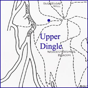
Upper Dingle
NGR 76729 45615
Site Number: C35
By Bruce Osborne and Cora Weaver (C) 2012
Area 4. West Malvern Springs and Wells
Malvern Hills, England
Description: a natural spring of crystal clear water that emerges beneath a grassy bank in the Cwm.
The strenuous but beautiful climb up from St Ann's Well and straight over the top of the hill is the pleasantest way to reach the top of the Dingle. Alternatively, climbing the footpath from the roadside tank, several containment and break tanks are revealed up the valley. These contain the spring water which can be heard through the covers of the tanks detailed in the section on Lower Dingle Spring.
To find the Upper Dingle spring, head for the marshy area in the depression high up The Dingle beyond the houses. Water flows out of the ground into a small pool. Because the spring is so high up, at 1044 feet above sea level, several moisture-loving plants can be found here that are normally only found much lower down the slopes, such as Mat-grass, Plume Thistle and rushes.
A dingle is a dell or small valley, and this dingle was carved over years and years by spring water flowing down the hillside. In the 19th century local people climbed up the hill side, collected the spring water in jugs and buckets, and carried it to their cottages. Excursionists drank here because it was on the easy route up to the Worcestershire Beacon, and wandering sheep also helped themselves. Following the formation of the Malvern Hills Conservators in 1884, these slopes came under their jurisdiction, and in 1890 they piped the spring water into a tank. This was much more hygienic but meant that there was no more water for the sheep to drink. It was not until a complaint to the Conservators in September 1904, which said that a sheep drinking trough was urgently needed near the spring source, that anything was done.
Illustrations:
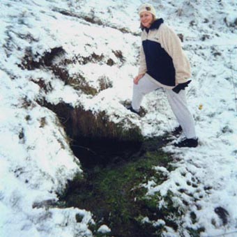
1. Chris Travis finds the spring in winter.
Website: Click Here
SUPPLEMENTARY INFORMATION

Celebrated Springs of
THE MALVERN HILLS
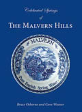 A definitive work that is the culmination of 20 years researching the springs and wells of the Malvern Hills, published by Phillimore. This is the ideal explorers guide enabling the reader to discover the location and often the astounding and long forgotten history of over 130 celebrated springs and wells sites around the Malvern Hills. The book is hard back with dust cover, large quarto size with lavish illustrations and extended text. Celebrated Springs contains about 200 illustrations and well researched text over a similar number of pages, together with seven area maps to guide the explorer to the locations around the Malvern Hills. It also includes details on the long history of bottling water in the Malvern Hills.
Written by Bruce Osborne and Cora Weaver, this book is available on-line for £15.00 (delivered UK) - click Malvern Bookshop on the green panel top left. Alternatively send a cheque payable to Cora Weaver with your name and address to 4 Hall Green, Malvern, Worcs. WR14 3QX.
1) TOPOGRAPHICAL LOCATION:
Malvern Hills - arguably Britain's original National Park
2) LANDSCAPE:
Uplands3) INFORMATION CATEGORY:
A Spring, Spout, Fountain or Holy Well Site4) MALVERN SPRING OR WELL SITE DETAILS:
Site with Malvern Water4 SPLASHES - Well Worth Finding

5) GENERAL VISITOR INFORMATION:
Access On FootFree Public Access
Free Parking Nearby
Accessible All Year