| 
|


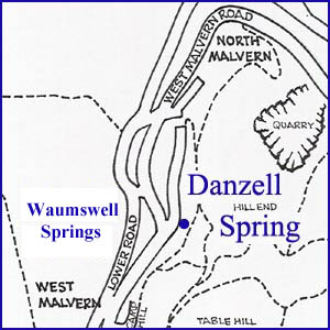
Waumswell(s) and the Danzell Spring
NGR 76534 46712
Site Number: C28
By Bruce Osborne and Cora Weaver (C) 2012
Area 3. North Malvern Springs and Wells
Malvern Hills, England
Description: an underground chamber reached by a deep shaft at the head of the valley and springs in the valley below.
1. The Danzell Spring
Access to the spring is by means of a deep shaft giving entry to an underground chamber. The iron cover to the shaft lies in a brick and stone surround alongside a contour path behind number 151 Folly Cottage, formerly Danzell Cottage, which is believed to be an old cider house.[2]
The water was used freely by the local inhabitants from the 1820s until it was contained for public supply under the Malvern Link (Extension and Water) Act of 1896.[3] In December 1898 the Surveyor, Mr Maybury, produced for the Council his plans for the better collection and distribution of the Danzell Spring. It became clear to the local people with an interest in the spring that their water rights would be interfered with as a result of the work and they met to consider claims for compensation.[4] Clause 49 of the Malvern Link Water Act of 1896 specified that the District Council 'must not sink any well, or construct any works for the purpose of abstracting underground water' and 45 owners and tenants signed a petition claiming free water if the Danzell Spring was diverted. They also asked for a new tank to replace the existing one, which was on private ground, and that any surplus water should be for public use. In return the Council could sink a tunnel for water.
The Council soon found underground water and, having done so, claimed that it was not from the Danzell Spring so the owners were not entitled to compensation. The owners were furious. Having had free water for 75 years the Council had taken the supply into the mains and left them none. They challenged the Council; the argument was debated; it was decided to allow compensation of 15 gallons per head per day reckoning on 5 members per household.[5] Later the Council maintained that Earl Beauchamp, who owned the nearby Birches Farm, was the only owner allowed compensation from the Danzell Spring.[6] So the controversy raged on until, under an agreement dated March 1905, local residents were awarded the right to receive water at a rate of 9d per 1000 gallons in perpetuity.
The threat to the water supplies of local residents erupted again in 1998. The Malvern Gazette featured an editorial 'Legal Threat to end cheap water deal'. This time Severn Trent Water was seeking to remove the entitlement of about two dozen customers who were receiving the water for the minimal charge. The water company claimed the water was unfit for drinking; the residents sought renovation of the spring to overcome the problem. There was also a dispute over who owned the spring - was it the Malvern Hills Conservators, on whose land the access shaft lies, or was it the water company?[7]. The 24 householders affected were H. Arnold, John Ballinger, W.H Biggs, Joseph Baughan, Samuel James Beddoes, William Clifford, Eliza Collicott, James Evans, John Evans, William Evans, J. Gwynn, Thomas Hammond, Jessie Sarah Hayes, A.H. Herbert, Joseph Hodges, Thomas V. Holds, Annie Jones, V.T Lloyd, Alfred Newell, Jane Pitt, Job Pitt, Charles Summers, Thomas William Trigg and Mary Webb.
The water has supplied the public main and serviced an area from Ebrington Road junction, West Malvern to the North Malvern Reservoir above Clock Tower. A bulk water meter, located on the footpath above Ebrington Road junction, formerly recorded the output from the spring. The meter has now been removed and the Danzell spring has run into the collector main since c.1970.
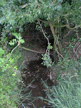
Between the old Methodist Church (number 139) and the old Bath House (number 141) is a substantial outfall from the Danzell Spring, which used to feed the Bath House. There is a further outflow below, on the downhill side of the West Malvern Road that provides water for a water garden in the garden of Ryecroft House, formerly the fire station.
Nearby a spout is reported to have once existed in the Y of the road junction between Old Hollow Road and West Malvern Road, near The Lamb public house.
Illustrations:
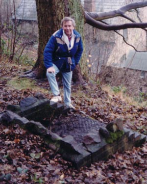
1. Bruce at the Danzell chamber access in the 1990s.
2. Ryecroft House outflow and water garden.
[1] Knight E M. 2000, The West Malvern Book, Cappella Archive, Malvern. p.3.
[2] Goodbury 1993
[3] Goodbury 1993
[4] Malvern Advertiser, 10 Dec 1898; 15 April 1899.
[5] Malvern Advertiser, 6 May 1899.
[6] Malvern Advertiser, 15 July 1899.
[7] Malvern Gazette 11 Sept 1998.
The large scale OS maps are extremely useful and all versions record immediately below and west of Lower Road. West Malvern - 'Walmspout Coppice'. The current A-Z Street Atlas also. This was promising as 'Waum' or 'Walm' is derived from the Old English wielm, meaning that which seethes or surges, a fount, upwelling or spring. 'Walmspout' was identified many decades ago as derived from wielm and it was noted that the earliest reference dated back to the thirteenth century.
George Demidowicz
West Malvern July 2017
1. Worcester Record Office BA1751/3.
2. WRO, BA1751/8.
3. Bruce Osborne and Cora Weaver, Celebrated Springs of the Malvern Hills (2012).
4. A Mawer and F M Stenton, The Place-names of Worcestershire, (1927) 67; J W Willis Bund and John Amphlett, Lay Subsidy Roll of Worcester circ.1280 (1893) Worcestershire Historical Society, 97.
6. WRO, BA 3375/19.
7. Copyhold land - held by copy of a manorial court entry, rather than as freehold or leasehold.
8. Westminster Abbey Archives, 146118.
9. Westminster Abbey Archive, 146118A.
10. Valerie Goodbury, West Malvern A History of the Village, (1994) 54-55.
11. Osborne and Weaver, 36-37.
Website: Click Here
SUPPLEMENTARY INFORMATION

Celebrated Springs of
THE MALVERN HILLS
 A definitive work that is the culmination of 20 years researching the springs and wells of the Malvern Hills, published by Phillimore. This is the ideal explorers guide enabling the reader to discover the location and often the astounding and long forgotten history of over 130 celebrated springs and wells sites around the Malvern Hills. The book is hard back with dust cover, large quarto size with lavish illustrations and extended text. Celebrated Springs contains about 200 illustrations and well researched text over a similar number of pages, together with seven area maps to guide the explorer to the locations around the Malvern Hills. It also includes details on the long history of bottling water in the Malvern Hills.
Written by Bruce Osborne and Cora Weaver, this book is available on-line for £15.00 (delivered UK) - click Malvern Bookshop on the green panel top left. Alternatively send a cheque payable to Cora Weaver with your name and address to 4 Hall Green, Malvern, Worcs. WR14 3QX.
1) TOPOGRAPHICAL LOCATION:
Malvern Hills - arguably Britain's original National Park
2) LANDSCAPE:
Rolling CountrysideUplands
3) INFORMATION CATEGORY:
A Spring, Spout, Fountain or Holy Well Site4) MALVERN SPRING OR WELL SITE DETAILS:
Site with Malvern Water4 SPLASHES - Well Worth Finding

5) GENERAL VISITOR INFORMATION:
Access On FootFree Public Access
Accessible All Year