OLD TOWN CROYDON is what the historic area around the Bishop's Palace and
Parish
Church is known by. Numerous streams and rivulets once crossed this area fed by springs in the immediate locality and draining off to the west as the Croydon branch of the River Wandle. Scarbrook Ponds were located down where the flyover crosses the valley between Duppas Hill and Fairfield Halls. Laud's Pond was between the palace and
Surrey Street. Harris' Mill Pond was opposite the
Parish
Church where
Roman Way is now. This was likely a mill site in Norman times. In addition numerous linear ponds associated with the Bishop's Palace were located in the Howley and Cranmer Roads area. The Wandle stream could be traced up as far as the Swan and Sugarloaf in
South Croydon. Here it picked up the seasonal Bourne Waters flowing down from Purley. Much of this network has disappeared or is culverted as a result of development in the nineteenth and twentieth centuries and a general lowering of the subterranean water table due to extensive pumping for public supplies.
Croydon in the early 19th century was seen by some as an attractive and memorable landscape. Ruskin records as a boy visiting his aunt in
Market Street where there was a crystal clear spring by the back door. Minnows inhabited the 'cress-set rivulets' and Duppas Hill, overlooking the valley was where you walked. For others however the seasonal deluge of the Bourne Waters, rising beyond Purley meant that the
Old
Town was flooded and became intolerable. In 1848 a damning report revealed that 36.6% of the Croydon community death rate could have been avoided if there had been a proper water supply and sewage system.
Immediately west of
Surrey Street the
Benson
Spring became the site for Croydon's first waterworks in 1851. This castellated building is generally thought to have been relocated from the Croydon Atmospheric Railway where it was a pumping station. This is not so, it was purpose built in three stages. It was the pumping engines and some building materials that were transferred. On 11th December 1851 the Archbishop started the pumps. Two wells were sunk here in 1851 and 1864 to draw water from. A third was sunk in 1867 and another in 1875. These yielded two and a half million gallons of water a day. The rest level of the water was 14 feet below ground level but when pumping to full capacity the level dropped to 27 feet below ground level. Pumping took place 24/7. All the wells passed through 3-4 feet of made ground and 11 feet of valley gravel before entering the chalk. The wells were then bored to a total depth varying between 150 and 264 feet.
The fountain at the junction of
Surrey Street and the High Street commemorates the widening of the High Steet in 1896. The Mayor was Frederick Thomas Edridge J.P., a name that frequently crops up associated with water features at this time. The fountain would have been supplied with water from the local waterworks below
Surrey Street but is now dry.
Contemporary with the building of the Croydon Waterworks, a substantial water reservoir was constructed under Park Hill, near East Croydon Station. This was a circular domed structure with cemented brickwork and a 75 foot diameter. When full it held 950000 gallons of water. The walls of the reservoir rose vertically for 30 feet and there were 16 arches, the wall piers continued as ribs in the dome roof some 12 foot above the maximum water level which was 32 feet deep. The water was pumped from
Surrey Street through a steel aqueduct carrying a 12 inch main into the base of the reservoir.
Park Hill Recreation Ground was opened on July 11th 1888 by the Mayor of Croydon Mr.J.W. Hobbs 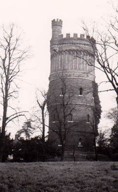 who lived at
Norbury
Park. Previous to this it had been a private estate. The year after the park was opened, Mr F.T. Edridge was elected a Councillor for the East Ward of Croydon, and he celebrated his victory by providing a bandstand for the Park Hill Recreation Ground, which became a favourite place for outdoor concerts and entertainments.
who lived at
Norbury
Park. Previous to this it had been a private estate. The year after the park was opened, Mr F.T. Edridge was elected a Councillor for the East Ward of Croydon, and he celebrated his victory by providing a bandstand for the Park Hill Recreation Ground, which became a favourite place for outdoor concerts and entertainments.
The rapid increase in houses in the vicinity however caused difficulties over the water supply in the neighbourhood. This was in spite of a 125 feet
high Water
Tower also being constructed at Park Hill in 1867. It was designed by the engineering firm
Baldwin and Latham but unfortunately provisions for supplying water still proved inadequate. A new reservoir was built on higher land at Addington Hills and the central site in Croydon was abandoned in 1923. The tower had been opened to the public as a viewing platform in 1889 and the reservoir was used temporarily in the 1939-1945 war as an Emergency Water Supply for fire fighting purposes. The tower survives to this day, albeit disused,
Picture right - Park Hill Tower 1975.
Another source of water for Croydon during the 19th century was the Addington Well and associated water pumping station. The steam powered pumping station was believed to be the last such facility to have worked in England, surviving as it did until 1975. The building was a listed building and it was hoped that this magnificent structure comprising two beam engines would be 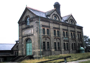 preserved as a monument to the water industry.
When Croydon first applied for permission to dig deep wells for public supply, a major consideration was the depletion of the water table that would prove detrimental to the River Wandle springs and volume of water entering the river. As a result the Corporation were restricted to a million gallons a day from the Addington source. The water was drawn from a shaft which was 200 feet deep and 10 feet in diameter. It was lined with brickwork for 51.5 feet and there were galleries in various directions between 100 and 150 feet down. It principally secured water from the Upper Chalk but is believed to have likely entered the Middle Chalk at its deepest. In 1887 when the well was completed the yield was just under 2.5 million gallons a day.
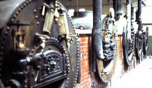
The station was opened by the Archbishop of Canterbury on 2nd August 1888 with one engine, built by Easton and Anderson of Erith. A second engine was erected in 1893 by Glenfield and Company, to the same specification as the original. The awesome facility when it closed was much the same as when first built, with the two original beam engines and five coal-fired Cornish boilers. Having survived as a working pumping station until the 1970s it was an industrial museum in the making. The buildings were listed by English Heritage after closure of the works
Unfortunately 5 courses of brickwork are all that remains of this listed building, one beam engine has gone to Strupshaw Hall and the other to Crossness. Now a modern pumping facility lies adjacent to the original site in Featherbed Lane, just south of old Addington village church.
Overlooking the Wandle valley and the surface water features of Croydon Old Town is Duppas Hill. Since medieval times there has been a history of use of Dubber's (now Duppers) Hill for sporting events, with tournaments held here until 1286, when Lord William de Warenne was treacherously murdered. At the age of thirty he was ambushed and slain following the Croydon tournament. The family were the Earls of Surrey and William had a year earlier married Joan De Vere. They had two children, Alice and John.
Duppas Hill today is still used as sports fields and has been used for many of Croydon's festivals and events over the years, including the annual firework displays presented by Sir Frederick Edridge, and bonfires to celebrate national as well as local events. In 1910 Lord Roberts presented colours to the 4th Queens Volunteer Battalion on Duppas Hill.
In 1726, the Vestry of Croydon resolved to erect the town's first workhouse at a site on Dubber's (now Duppas) Hill. The establishment was open by the end of the following year and governed by a committee of Trustees. By 1862, the existing workhouse had become unable to cope with the increasing number of paupers that had accompanied the growth of Croydon. On 24th May 1865, the foundation stone was laid for a new workhouse on a 4.5 acre site at the east side of Queen's Road in Croydon. The new building was opened on 25 September 1866 and the facility moved to north of Croydon.
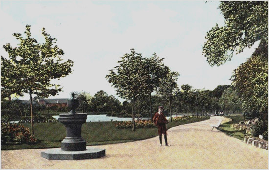
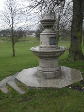
This led to the creation of a public park at Duppas Hill since 1865, when the Croydon Board of Health bought land from the Ecclesiastical Commissioners for two thousand pounds to create Croydon's first recreation ground. It was laid out with paths and an ornate drinking fountain. By 1932 a bandstand, pavilion and another drinking fountain had been added.
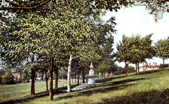
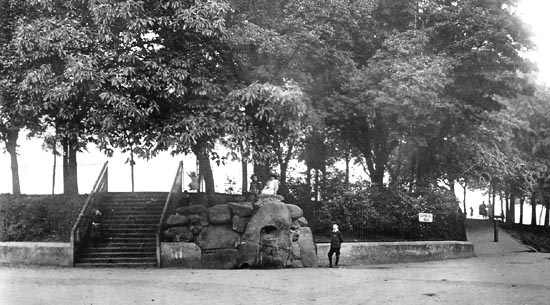
Pictures above - two views of the earlier fountain in the park, one as it is today and the other as it was circa 1920.
The two fountains survive albeit both are now dry.
The first lies on the hill in trees in the middle of the park. This is the original fountain and was the gift of James Spurrier Wright 1886. The Surrey Mirror records the event on 1 May 1886.
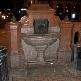
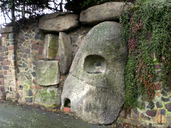
The second is an informal arrangement of boulders with a water spout in a cavity in the rock with a dog trough below at the
Duppas
Park entrance. Coming over the flyover towards Waddon, the nearside lane turns left in front of the park. The fountain is on the corner as you turn.
The picture above is recent whereas the picture below is circa 1920, showing that the fountain has been restyled.
A further water feature survives at the Waddon Public House at the lower end of Duppas Hill. This is a cattle trough and can be seen at the roadside. 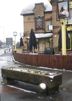
The caption on the trough reads: Presented by the Metropolitan Drinking Fountain and Cattle Trough Association.
The London based Metropolitan Drinking Fountain and Cattle Trough Association was an association set up in 1859 by Samuel Gurney an MP and philanthropist and Edward Thomas Wakefield, a barrister, to provide free drinking water. Samuel Gurney (1816 - 1882) was related to Elizabeth Fry and MP for Penrhyn and Falmouth, He was the second son of banker Samuel Gurney (1786-1856). Originally called the Metropolitan Free Drinking Fountain Association, it changed its name to include cattle troughs in 1867, to also support animal welfare. It was linked to the Temperance Movement believing that the provision of drinking water would reduce drunkenness and misbehaviour' . For more details see sections on Carshalton and Wilderness Island.
The Swan and Sugarloaf in South Croydon was where the Wandle once first appeared as a stream. This building is now a Tesco Express and there is no sign of surface water in the vicinity. As can be seen from the picture below which dates from the early 20th century, there was a cattle trough located outside the public house.
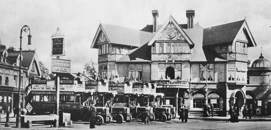
Near the present day Swan and Sugarloaf building, a Cattle Market was established in Croydon in 1848. The market was used by butchers from south London and benefited the farmers of the counties of Kent, Surrey and Sussex. It could accommodate 200 calves, 1,400 sheep and pigs, and 200 head of cattle. Good drainage, paved walks and covering was provided. An unusual circular cattle and dog trough was installed in the market. The inscription on the outer edge of the trough reads: THE GIFT OF H. PRATER ESQUIRE M.D. 1882. It comprises a circular drinking trough of granite. The trough has a curved inner profile which forms a ring around a raised central pedestal. The outer edge of the trough curves inwards to form a recessed lip.
The cattle market closed in June 1935, and was demolished to make way for flats. The only artifact of the market that can be seen today is the cattle trough that has been relocated to Norbury Park. The memory of the market remains in the name of 'Drovers Road' - a reminder that sheep and cattle were driven to the market on foot from many miles away. For more details of the water feature and Norbury Park go to River Graveney and Norbury Brook below.
The Croydon Cattle Market in 1851 is illustrated here. Livestock, driven from vast distances provided a vital food source for the ever increasing populace of Croydon and district.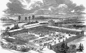
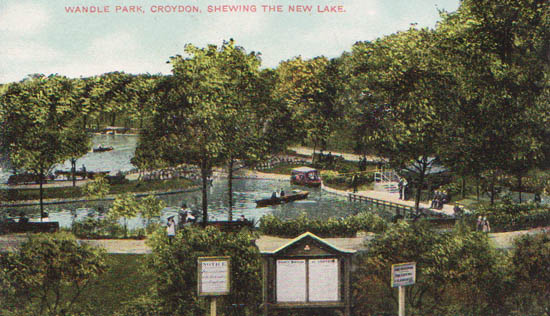
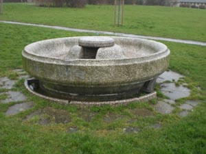
Wandle Park in Croydon was known as Stubbs Mead before it was transformed in 1890 when the area was landscaped to provide boating lakes. Thecourse of the river was moved to the north of the park area and the lakes located south. The lakes were fed by ground water and not directly by the river. Eventually the lakes became permanently dry. Unfortunately in the 1960s Wandle Park, where once peopchmitz to commemorate the opening of Wandle Park in May 1890. The park became a popular leisure resort with boats for hire. The fountain was restored in 2012/3 as part of a project to reinstate the original mid 19th century course of the river.
The boating lake and fountain in Wandle Park circa 1900.
Something of a mystery surrounds the Schmitz fountain however. Croham Hurst is the 33.6 hectare ancient woodland in South Croydon. It belonged to the Whitgift Foundation in the late 19th century when it became noted as a public recreation area. Threat of development resulted in the site being acquired by Croydon Corporation in February 1901. Early pictures of the entrance area to Croham Hurst show a signboard headed County Boro of Croydon and a fountain identical to that recently restored in Wandle Park as illustrated above. The question arises were there two fountains or was the Croham Hurst fountain removed to Wandle Park, and if so when? There is certainly no longer a fountain at Croham Hurst! (see 6. The Bournes below for more details of the Croham Hurst fountain)
The boating lake in Wandle Park circa 1900.
New Look Wandle Park
- In the 1960s the river through Wandle Park was piped underground. Landscaping in the early 21st century enabled the river to be revealed again. By the autumn of 2013 the grass had grown and scrub was starting to appear in the river gorge that now snakes through the park. This unfortunately gave the impression of wasteland rather than a picturesque landscape. Experience elsewhere indicates that a 'Capability Brown' landscape requires imagination and time to develop. Trees and sympathetic low level vegetation are now developing along the river gorge. This will take time and observers should not be daunted by initial impressions. Within the park is the water fountain as illustrated above.
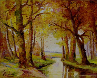
Picture right - The Wandle near Beddington - from an original oil painting, circa 1915.
At the eastern end of
Beddington
Park are St Mary's Church and Carew Manor. Both are thought to date back to early medieval times. Later the Carews added a
deer park. Sir Francis Carew (1530 -1611) laid out extensive water gardens with grottoes and fountains as part of a general landscaping of the surrounds. Queen Elizabeth is known to have visited the Carews. The estate was broken up in the mid nineteenth century. Canon Bridges, rector of St Mary's from 1864 - 1891 acquired the park that we would recognise today, adding many of the 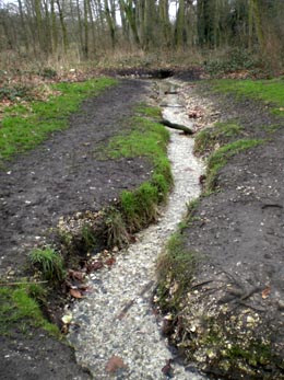 features including some of the bridges over the Wandle. George Payne of 'poppets' fame, a local entrepreneur was the benefactor that allowed the park to fall into public hands in the twentieth century, when it was acquired by the Borough Council.
The River Wandle snakes its way through the park from east to west, its course having been modified over the years. A feature of the park is the springs that supplement this Croydon branch of the Wandle. These manifest themselves in a variety of ways. There is a lake to the north of the river, fed by spring water and feeding into the Wandle via an underground pipeline. Elsewhere a distinct spring and channel can be seen with water emerging from the chalk. The flow of clear spring water is substantial and many a mineral water bottler would give much for such a water source.


 Springs, Spouts, Fountains and Wells of the River Wandle - 2